Westward Wanderlust Day 17
Fire Road 15564, near Yosemite National Park, CA
July 26th, 2012
Waking up camping is one of my favorite moments in life. I often experience that momentary “Wait – where am I?” feeling as the stratums of sleep are peeled away. But instead of panic following this flash of obscurity, it is followed by a sensation of relief, release, and delight. The litany of objectivity inspires me to wakefulness: I am lying on the ground. I am in a tent. I am camping. I am outside. I am in nature. I am awake.
As we broke camp in the morning light, we could see the sand clouds we had imagined in the dark the night before. There was a fine layer of tan dust on everything, minuscule bits of Earth clinging to any exposed surface. Dusting ourselves off as best we could, we were back on the road by 7:00am. The sun was shining confidently through the trees along the dirt road and it was 49 degrees. We arrived at Yosemite within the hour.


Yosemite tunnel.


What a beautiful morning!


Fern Spring, Yosemite


We headed through Yosemite Valley toward Yosemite Village. A stop at a small shop touting a variety of handmade artwork, jewelry and other souvenirs led us to the magnificent discovery of fresh coffee. We walked to the Yosemite Visitor Center to acquire a passport stamp. The national parks passport is an excellent way to keep track of the parks you visit, log your travels, and create a unique souvenir. Each park has a dated park stamp that you can ink and press onto anything. You can purchase national parks passport book at most visitor centers (as we did on our visit to the Apostle Islands Lakeshore center in WI last summer) and catalogue your visits as you would in an actual passport. You can also get creative and stamp your journal or a notebook, an idea that didn’t find me until we reached Olympic. A travel journal is the best way, in my opinion, to record a trip. There are so many moments and details that are as easily forgotten as they are enjoyed. Taking the few minutes to write down or draw what I see, feel, smell, and experience becomes worth the effort. There’s a rhythm, familiarity, and pleasure to the travel journal gained through the acquisition of the habit. And you don’t have to be a writer or an artist to create a custom memento of your experience. I have seen several excited kids come barreling into a park gift shop or visitor center, scanning and circling the perimeter for the stamp station. As soon as they see their prize, they bolt for it, clutching the spine of a book, pages flapping back and forth with each bounding step. We contracted this contagious enthusiasm and enjoyed taking turns seeking the stamp station at each park. Some parks even include addition options beside the date/park stamp, like Olympic, which offered a stamp that left behind the outline of the illusive banana slug.
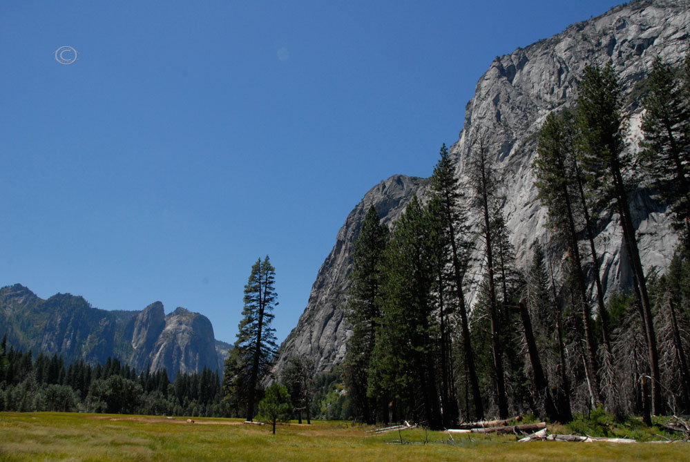
This morning, however, we had gotten such an early start that the visitor center was not open yet. So we sat back, enjoyed our coffee, and admired the view behind the dark park building. Three mountain peaks stood in a crowded row like a trio of stone tenors, their broad shoulders sidled along side one another, all vying for the solo position. The morning sun shown on their faces like a muted spotlight. Ponderosa Pine, Incense Cedar, and California Black Oak grew from the base of the mountain and clustered to the edge of the park sidewalks. A few brave Ponderosas reached skyward from the very top of the mountains, their silhouettes like stray hair ruffled out of place by quarreling mountain egos. I did my best to try and sketch this scene in my journal, and then headed in for the stamp as soon as the building opened. It was 57 degrees at 8:30 am.

Waiting for the visitor center to open.
Photo by D.R.J.
We hiked to Lower Falls trail and followed it to get a look at Yosemite Falls.


Educational signage!
The tallest waterfalls in North America, Yosemite Falls stands 2,425 feet. But to our surprise, compared to the images we had seen of Yosemite Falls in nature documentaries, the cascading water was a mere trickle.

Lower Yosemite Falls
The tumbles of boulders at the base of the falls that were usually covered with rushing water were dry enough to climb on, as many park visitors were doing. We consulted our park literature, “A Changing Yosemite- A Self-Guiding Trail”, and found that this state of the waterfall is often the case in late summer or autumn. Since melting snow is the main source of water for Yosemite Creek, which rushes over the precipice of the granite wall to the floor of Yosemite Valley, no snow means no falls.

Lower Yosemite Falls – See the people on the rocks?

Lower Yosemite Falls

D deep in thought at Yosemite Falls.

As the sun took command, the day grew hotter. The sky was a fantastic sapphire blue and not a cloud was in sight that would diffuse the burning embrace of the sun. We walked to Yosemite Lodge, then back to the car to change into lighter clothes.

Could the sky BE any bluer?

Ahhhhh. Warm summer sun. Thank you.
We meandered on and found ourselves along the banks of the Merced River. The river was very inviting and I wanted to take a dip, or at least dunk my head to cool off a bit. A curious duck swam by, looking very cool and relaxed, and gave me a few pointers.


Along the Merced River
We found a perfect spot along the riverbank with an unobstructed view of Half Dome.

What a view! Half Dome, Yosemite

Wow! Half Dome, Yosemite
D walked back to one of the Yosemite convenience stores to grab refreshments and I excitedly unlaced my tennis shoes. I stepped into the Merced and was at first startled, then energized. The water was very cold, but incredibly refreshing. I traversed the stony riverbed into deeper water. Planting my feet I leaned over and plunged my head into the bracing river. Shivers ran down my spine and welcome chill spread through my body like a tremor. So invigorating! So amazing!

Wading in the Merced River – Photo by D. R. J.
Ducks gilded with ease along the current as swallows zigzagged above the surface of the clear water. The riverbed was carpeted with mineral and marble stones, mica flakes glimmering beneath the surface giving a hint of what early prospectors were at once elated and dismayed by.

Ducks on the Merced – Photo by D. R. J.

Here’s to the Half Dome!

Half Dome, Yosemite
The view of the mighty Half Dome in the distance was magnificent. The granite dome rises nearly 4,800 feet above the valley floor and was “declared perfectly inaccessible” until the 1870s. Now, in addition to 300 permits to climb the dome that are released per day during a preseason lottery, about 50 permits are available each day, also by lottery, during the hiking season (late May through early October). Not exactly experienced climbers, we were content to enjoy Half Dome from afar as a dramatic, one-of-a-kind backdrop to a beautiful summer day. The landscape couldn’t more perfect for our seemingly exclusive bend in the shining river.

Can you find the D?

There he is…testing boundaries. Shocking.
Robins splashed in shallow pools on the opposite bank as we enjoyed a riverside picnic and a local brew, savoring our relaxing and refreshing commune with the Merced River.


Banks of the Merced

Even though we were in a place that receives 3.9 million visitors annually, our spot was very quiet and private. It wasn’t until we were starting to gather our belongings to leave that anyone else even passed by our picnic. Rejuvenated and re-energized, we continued through Yosemite Valley.

Can you imagine spending every weekend here? I can!
As soon as we began driving again, we pulled over, got out of the car, and stood in awe of El Capitán. The largest granite monolith in the world, El Capitán looms over the valley meadows.


A hot wind swelled across the meadow, waving the tall green and golden grasses and blowing in our faces. We stood with our faces to the hot summer squall and gazed at the great granite giant.


As D took a few pictures, he realized he had made a little friend. It was remarkable that this tiny being was not blown away by the strong gusts that surged across the valley.

Hey little buddy!

We resumed our voyage and headed toward Tunnel View, one of the most photographed vistas in the world according to Mike’s book, and Glacier Point where some of the best views of Half Dome and Yosemite Valley can be seen.

In the tunnel

Tunnel View. WOW.

Well, there goes MY afternoon!

So many spectacular views.
It was 77 degrees and sunny as we drove up Glacier Point Road. Jimi Hendrix coaxed us on, his gravel voice tumbling through the sweet, smooth river of his guitar, Gets very lonely up this road baby…


We continued along the climbing, curving road until we reached Glacier Point. The view was breathtaking.


Half Dome looked like a massive stone monk, hooded and seated in motionless mediation. It was as if the devotee had been sitting in reverence to nature so long and so fervently, that he became the very mountain itself. The feeling of sanctity here was quiet, but powerful. This was no doubt one of the places John Muir had in mind when he wrote that Yosemite “must be the sanctum sanctorum of the Sierra (the holiest of the holy places)”. We sat silently and enjoyed the scenic tranquility.


D looking out from Glacier Point.

Now those are some determined trees!

Amazing.
Before we left, D and I took turns lying on our stomachs and staring into the glacier-formed valley. Wind filled the great void below, gusting up the steep granite walls and over our awestruck faces.
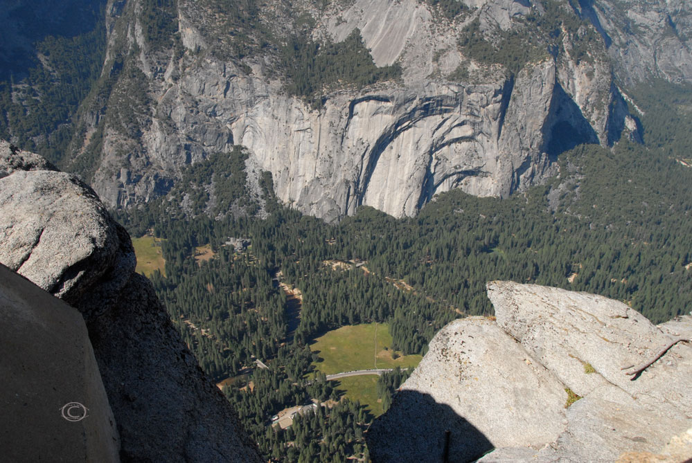

Photo by D.R.J.
We finally tore ourselves away from the amazing panorama and were back on our way. The steep serpentine road bent along the brink of rock face, edging the precipice with each sweeping turn.

Not much room for error here…

Oh good. My favorite!
We drove south on Wawon Road toward the Mariposa Grove of Giant Sequoias.


Mariposa Grove
Then, south on CA Hwy 41 toward Fresno and east on Hwy 180 to ward Kings Canyon and Sequoia National Park. The highway was suddenly slicing through endless stands of fruiting trees. We were surrounded by abundant olive and orange groves. Lush lines of orange and olive trees flanked us on both sides as we sped down the sizzling California asphalt. The fruit trees flourished in this seemingly arid landscape, making my mouth water for the fresh flesh of a plum or nectarine. It was too late for fruit stands though, each one we passed stood shadowed and absent of merchant and merchandise.

As we drew near our destination, the sun glowed low in the western sky.


We arrived at Kings Canyon at dusk and were able to snag a campsite at Azalea Campground.

It was dark by the time we pitched our tent. D strummed quietly on his guitar as I wrote in my journal. We made a delicious grilled cheese and hash brown dinner over our campfire and enjoyed the warm glow late into the night.

Grilled cheese and hash browns – yum!
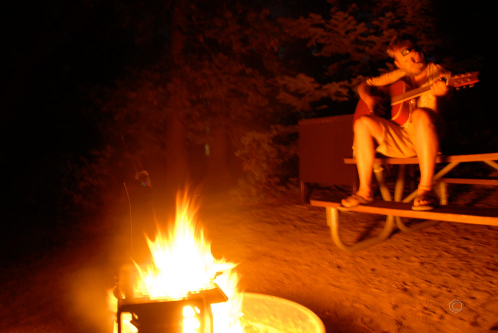
D strummin’ fireside.
Tomorrow we would be back on the trail, exploring the home of the third largest living thing in the world, Kings Canyon National Park, and famed the largest tree on Earth in Sequoia National Park.
But for now, all we needed was to sit beside each other and enjoy the calming campfire glow on this quiet California night.

Camp
Westward Wanderlust Soundtrack Day 17
Driving to Glacier Point – Jimi Hendrix “My Friend”