Westward Wanderlust Day 20
Zion National Park, Utah
July 29th, 2012
After a night in our comfortable king bed at the Majestic View , we woke rested and ready for our Zion adventure. It was 82 degrees at 9:00 am.

Zion National Park

Good morning Zion!
The canyon walls soared skyward, displaying their colorful rock layers. These beautiful bands of stone and sand denote over 150 million years of erosion and environmental change. Today, the Virgin River continues to flow through the canyons, moving rock and eroding the canyon at a surprising rate of 5000 tons of debris daily.

Zion National Park
The formation of Zion’s magnificent cliffs is also affected by rain fall on the 11,000-foot-high- Colorado Plateau located north of Zion. According to the NPS Zion literature, rain “races downhill, slices Zion’s relatively soft layers, and pushes its debris off the Plateau’s southern edge. This edge is not abrupt, but steps down in a series of cliffs and slopes known as the Grand Staircase”.

It does kind of look like stairs, doesn’t it?
Located above Zion, the Grand Staircase is topped by Bryce Canyon (our next destination) and below Zion, the Grand Canyon forms the base of the staircase.

The name Zion translates to “promise land” or “sanctuary”, which the Virgin River Valley has been for many ancient cultures, settlers, and explorers.

We stopped at the visitor center to stamp our passport, then decided to take a drive through the park to get an idea of where the various attractions are located.

One of the first realizations we had about Zion is that unlike many of the parks we had visited prior, it is not really designed for travelers to cruise in their own vehicles. During the peak season, most roads that lead to the various hikes are only accessible by park shuttle. Before we realized where we were, we were on a steep road with no turn around spots that was leading us straight to the Mount Caramel Highway and Zion-Mount Caramel Tunnel, which leads you out of the park.
After some jockeying for position and an encounter with a park ranger, we were turned around and headed back into the park.

Yep, turning around. Oops!
We returned to the visitors center parking area, poured over our park literature and figured out how to make our way to our goal for the day, Angel’s Landing. To get to the famed hike, we took the park shuttle to the Grotto stop then started our trek.

View from shuttle ride to Grotto Stop.

View from shuttle ride to Grotto Stop.
There were a few reasons that culminated in our decision to attempt this particular hike. First, we a few months ago we were talking to our friend Mandy about the road trip we had planned for this summer. When we mentioned that Zion was on our list of destinations, she enthusiastically recommended the Angel’s Landing hike. Mandy described it as “amazing”, “awesome”, “incredible”, and “something you have to do”. Mike’s book also described Angel’s Landing as “one of the most memorable hikes in the National Park System”. Always up for an adventure, Mandy and Mike’s endorsements were enough to sell us on this hike. Soon after we began however, it became apparent that this would truly be unlike any hike we had ever done before.

Thanks park signage. Oh boy…
(Photo by D. R. J.)
The trailhead begins with a bridge over the Virgin River, then heads north as it links with the West Rim Trail. The West Rim trail is a steady and steep uphill trudge to the mouth of Refrigerator Canyon. This paved section of the trail, bordered with junipers, cottonwoods, and pinion pines, winds up the west side of the canyon as it continually gains elevation.

Super steep canyon walls looming over the trail. (Photo by D. R. J.)
As excited as I was to complete this hike, I began to realize it was possible I had no idea what I was getting in to. As we marched this first section of the trail, I was already lagging behind D. I didn’t want to slow him up, but there was no way I could keep up with his accelerated pace and not run out of steam. I could feel my calves as tense and tighten as I slogged on, each step steeper than the one before. This was going to be a test of our endurance as well as our patience. I set myself on our path and pushed on. D slowed his pace and allowed me to catch up. We continued around the next curve, up the next straightway. When we reached Refrigerator Canyon, I welcomed the cool air and shade held in the deep hanging canyon walls. Here, the incline let up a little and my calves momentarily relaxed as we walked. I took a moment to sit and collect myself and enjoy the welcome change in our hike. After a minute or so, we continued along and it became apparent path would not remain level for long.

Refrigerator Canyon (Photo by D. R. J.)
The path looped back around the mouth of the canyon and we faced our ascent up the canyon wall, a path consisting of succession of 21 switchbacks carved in the steep canyon wall known as “Walter’s Wiggles”. The impressively compact series of switchbacks were cut into the solid rock wall by the Civilian Conservation Corps (C.C.C.) in 1926. Named after the park’s first superintendent Walter Ruesch who helped design this engineering feat, this section of the path is more than a bit intimidating. At this point, the elevation is about 5100 feet, 810 feet of which we gained in about the last 2 miles. Another 250 feet are gained going up Walter’s Wiggles.
I stood looking up the twisting trail and felt a sick sinking inside my stomach. The canyon was sheer and looked almost vertical. I do not have a fear of heights that I am aware of, but something about this impending path made me uneasy. But I couldn’t figure out what or why. I was, hot, sweaty, and already a bit weary, but I wanted to keep going. It was going to take me longer than we expected though. I told D to keep going – I would have to go at my own pace. He didn’t want to leave me, but he also was not feeling nearly as nervous and semi-drained as I was. I implored him to keep going and he did, but with some resistance. He went on a switchback or two ahead as I pressed on. My lungs began to ache as I slowly ascended and I felt like I was gasping with each switchback bend. The elevation seemed to be taking its toll and I stopped several times to catch my breath. Soon, D was beside me concerned for my welfare. Without warning, I tears began to stream down my face. I was frustrated and fatigued, as well as confused by my emotional outburst. I was not scared, but I was irritated with myself, my inability to keep up, and puzzled by my nervous reaction to the trail. D began to wonder if we shouldn’t turn back, concerned that if I was in this state now, what would happen when we reached the intensely challenging, and much higher, section of the trail? He told me he didn’t want me to freeze up. I became angry at this notion and insisted that I would be fine. I just needed to take my time. (As I said, a test of endurance as well as patience.) He was frustrated with but concerned for me, I was frustrated with him, myself, and Walter and his freakin’ Wiggles. I mean come on, who designs a trail like this?! I was especially frustrated with myself though. My response to the challenge of this hike had become emotional instead of physical and I was unprepared to deal with that. Why am I so upset? Why am I so nervous? I’m not afraid of heights, damn it! What the hell is my problem? However, berating myself was not the answer to this problem. I realized that the only way to deal with this was to push through. I calmed down and we continued to wind along Walter’s Wiggles.
Walter’s Wiggles finally lead us to Scout’s Lookout, and a very welcome break. At 5,350 feet, Scout’s Lookout is a flat triangular landing that provides a view of a portion of the climb to Angel’s Landing. The last 0.5 miles of the trail follows the backbone of a narrow rock fin. I gazed up at the tapered sandstone spine and gasped. The path was tight, narrow, and precise, gaining another 435 feet in elevation, as it stretches out over the canyon floor. Other than jutting rocks and ledges, the only thing you can use to guide yourself along the trail are thick metal posts driven into the sandstone with lengths of heavy chain stretched between them. Each post and chain “rail” is spaced strategically along the most treacherous and unforgiving sections of the trail, allowing hikers a sturdy, specific method to guide themselves across the rock fin. Many sections of the trail are completely exposed on one side, with nothing between you an over 1,000 foot drop to the canyon below.
Tears reappeared as I gaped at the path before us and wondered how in the world anyone could possibly traverse this precarious path. Maybe D had been right. Maybe I shouldn’t have come up here. I couldn’t do it. I just couldn’t. I sat stewing with myself as D scrambled around on the rocks. Why was I so afraid? Did I not trust myself? My footing? The chains? What was the problem here? It was not so much the fear of the height, but the fear of falling from the height that was getting to me. The knowledge that one wrong step was all it would take. But why was I assuming that I would take the wrong step? It’s not like I have never been in risky situations that required sure footing, quick decisions, or trust in my own balance and body before. Why was I not allowing myself to do this? I began thinking about what had brought us here in the first place. Many factors had contributed to our decision to take this trip, but the major reasons were our shared ambition not only to visit all of the National Parks together, but to take advantage of our lives by filling them with as many amazing experiences as we could. For the first time, we were both teachers and we both had our summer off. We had to take advantage of it. We had saved and hoped through the school year with the intent of taking this trip and have loved every moment of it. Our love for the natural world is strong, as is our desire to experience and understand it first hand. As we have tried to practice over the last few weeks, this means traveling, going new places, trying new things, and taking risks. I though about my own demons, my own need to finish what I start, to not back down, to not second guess what I know in my heart, and to trust me to make the right decision for myself. This means understanding and respecting fear, but not confusing it with doubt. This means listening when I tell myself I can do it. This means going to Angel’s Landing.
I rehydrated, refocused, and renewed my nerve. I can do this.
I flagged D down and told him I was ready. He smiled. He asked me if I was sure. I looked at him and said “Yes. I can do this,” he looked at me and answered, “ I know you can.” Together, we started up the final section of the trail.


Partial view of lower part of trail from Scout’s Lookout to Angel’s Landing. Don’t forget to breathe.
The fin is made of sandstone, which adds an extra element to account for. The path is well-worn, the steps smoothed by countless carefully placed tennis shoes. I took each step cautiously yet confidently, focusing on the task at hand rather than my perilous surroundings. The first area that allowed enough room to step aside from the trail and catch my breath, I did so, then quickly realized that it was better to just keep going. I fixed my eyes on the trail before me, moving hand to rock, foot to path, hand to rock, foot to path. As the rock fin rose higher and curved sharply, I kept on; foot to rock, hand to chain, foot to path, hand to chain, foot to path, hand to chain, hand to chain, foot to rock, hand to rock, foot to rock, and body forward. Though I did not look, I knew the canyon wall plunged over 1,000 feet beside me. I gripped the chain and willed myself on.

I’m not kidding. Whoa. I’m glad D took this photo because I couldn’t… (Photo By D. R. J.)
In some areas where the “rails” lay against the ground or wall, the chains lay flush with the rock. Years of wind and weight rapping the chains against the easily eroding sandstone had worn grooves in the rock, reminding me just how fragile the matter I was climbing was. I focused instead on the heft and strength of the thick links of chain and how thankful I was that they where there, ready to assist me.
Aside from the sheer, steep line of the path, the other difficult aspect of this trail is the fact that you are not the only person on it. Any number of other park-goers are mounting the same challenge you are, which means that sometimes you need find a place to stop and allow people coming down to pass you, or wait for other people going up in front of you to move before you can proceed.

Water break… just don’t look down. (Photo By D.R.J.)

D enjoying the view, of course.
As we climbed, we were met words of encouragement from hikers coming down from Angel’s Landing. Perhaps my countenance betrayed my unease or maybe some of them had encountered the same difficulty I did pushing myself to the top, but the array of “You can do it” and “You’re almost there” support was genuine and welcome. After what seemed like a long time, but was likely not, we scaled the crest of the fin and finally came to the summit.
We had done it. I had done it. On the first day of my 30th year, I had conquered Angel’s Landing. There we stood, 5,785 feet above sea level. There was still another 100 yards or so from the summit to the lookout point, but first I sat against one of the remarkably hearty juniper trees that grow straight out of the rock and enjoyed our accomplishment.

MADE IT! (Photo by D. R. J.)

Angel’s Landing
I wasn’t ready to venture to the edge just yet, though D wasted no time making his way to the precipice.

Photo by D. R. J.

Photo by D. R. J.

Photo by D. R. J.

Photo by D. R. J.
Once I got my bearings, I made my way to the brink. The view was unbelievable.

Holy cow! (Photo by D. R. J.)

Photo by D. R. J.
The 360 degree view from Angel’s Landing allowed us an outstanding view. Below us was The Organ and the Big Bend in the Virgin River, and across the canyon was the mouth of Hidden Canyon, the Great White Throne, Cable Mountain, and The Weeping Rock.

Amazing! Photo by D. R. J.
I couldn’t believe we had climbed this high!

Agh! So happy! (Photo by fellow hiker)

So awesome. (Photo by fellow hiker)


As I gawked at the brilliant canyon walls and the staggering natural beauty before us, I was so thankful and proud that we had made it here. It was worth the effort, without a doubt. I even felt comfortable enough to climb just a little higher.

Even higher on Angel’s Landing! Wow. (Photo by D. R. J.)

Of course. D was loving it up there.

Together on Angel’s Landing! (Photo by fellow hiker)
We had not been on Angel’s Landing long before we began to notice the dark skies in the distance. As much as we wanted to stay up there and relish our accomplishment, D suggested and I agreed that the weather may force us to do otherwise. The idea of being caught anywhere on this hike, especially the hair-raising 0.5 mile stretch between Angel’s Landing and Scout’s Lookout was more than enough to get me moving. We started the trek back down the sandstone fin, along the chains and the narrow path. The way down seemed a bit easier, since I had done it once already, though it was still a very serious descent not to be taken lightly. This time, it was my turn to smile at the frightened faces of upward bound hikers and offer words of encouragement and positivity; “You can do it,” “You’re almost there,” “It’s totally worth it”.

The hike down…still pretty intense. (Photo by D. R. J.)
As amazing as it would have been to have more pictures of the entire hike, I was in not state to be worrying about a camera, and on such an adventure, it seemed best to focus on the task. We snapped photos when we could, (D especially got some great ones) a few of which give you an inkling as to the severity and intensity of this awesome trail.
(To get an idea of the Water’s Wiggles portion of the trail and the size of the entire fin, check out this poster from ZionPark.org)

Climbing down the fin with the help of some of the chains. (Photo by D. R. J.)

Oh yeah, that’s right. We were up there! (Photo by D. R. J.)

Incoming storm (Photo by D. R. J.)
D couldn’t have been more accurate with his weather forecast, because as soon as we cross the bridge over the Virgin River and headed for the shuttle stop, it began to rain. I cannot imagine what you would do if you were caught on Angel’s Landing in the rain. Thankfully, we were on the shuttle and headed to our car. The rain let up for a bit after we disembarked the shuttle and we made a few turkey wraps and sat along the Virgin River.

Along the Virgin River

Zebra-tailed Lizard (Callisaurus draconoides)
More than content with our Zion experience, we were soon back on the road and headed to our next destination, Bryce Canyon. We retraced the path we had mistakenly taken earlier toward the Zion-Mount Caramel Tunnel.

The original purpose of the tunnel was to provide direct access from Bryce Canyon and The Grand Canyon to Zion. Construction of the 1.1 mile tunnel began in the 1920’s and was completed in 1930. When it was dedicated on July 4th, 1930, it was the longest tunnel of it’s kind in the United States.
The tunnel boars straight through the rock, providing drivers with the one of a kind experience of driving through the middle of a mountain. But even more unique is the fact that there are windows carved in the side of the tunnel giving drivers small glimpses of Zion’s striking scenery. However, due to the fact that the tunnel is carved through sandstone, much reinforcement has been necessary over the years. Now, concrete ribs run the length of the tunnel, giving needed support and the tunnel is electronically monitored 24 hours a day to keep park officials abreast of the danger of possible collapse. So in we go!

Heading into the Zion-Mount Caramel Tunnel (The sign ahead reminds drivers that the tunnel is dark so you should remove your sunglasses before entering. Thanks NPS!)

Woo hoo! In Zion- Mount Caramel Tunnel!
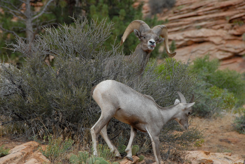
After we emerged from the tunnel unscathed, we were greeted by a small group of regal Desert Bighorn Sheep.
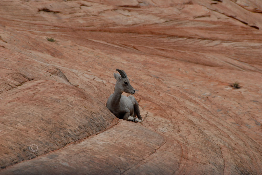
Female Desert Bighorn Sheep (Ovis Canadensis Nelsoni)

Female Desert Bighorn Sheep (Ovis Canadensis Nelsoni)

I think we’re interrupting something… Female and Male Desert Bighorn Sheep (Ovis Canadensis Nelsoni)

Female Desert Bighorn Sheep (Ovis Canadensis Nelsoni)
Guess he’s done posing…
Female and Male Desert Bighorn Sheep (Ovis Canadensis Nelsoni)

Male Desert Bighorn Sheep (Ovis Canadensis Nelsoni)

Male Desert Bighorn Sheep (Ovis Canadensis Nelsoni)

Male Desert Bighorn Sheep (Ovis Canadensis Nelsoni)
We continued east on Utah Hwy 9 right into the approaching storm.


As we steered through the driving rain, we discussed our next stop. Was it worth seeing Bryce Canyon in the rain? Neither one of us knew much about the place, and also knew we had a haul ahead of us to make it to Arches. We hemmed and hawed over our travel options, and finally decided that we might as well check out Bryce Canyon since it was right on the way. Why not?

Driving through Utah (Photo by D. R. J.)

Driving through Utah (Photo by D. R. J.)

Yeah, I don’t really believe your signs.

Especially with all of your mixed messages. Open 24 hrs…closed? Hmmm.
We followed Hwy 9 North along the Dixie National Forest, coming closer and closer to Bryce Canyon.

Restaurant AND horse rides??

AND TEEPEES?! Sweet!
It was 6:00 Mountain Time, 55 degrees, and raining when we entered Bryce Canyon National Park.


Look our for horses…and really big prairie dogs.


The park road led us slowly through the rain and mist. The atmosphere reminded me of the Smokey Mountains, the soft grey fog quietly weaving through the dense stands of trees that lined the road. White Fir, Spruce, and Aspen and Bristlecone Pine reached toward to cloudy white sky, their leafy fingers waving at us on as the wind rocked them side to side. With the rain and cool weather that had moved in, we seemed to be the only people trolling the park. We pulled up to the first viewing point and caught our initial glimpse of Bryce Canyon.

Helpful park signage – but so demanding!


Farview Point, Bryce Canyon

Farview Point, Bryce Canyon

Farview Point, Bryce Canyon

Farview Point, Bryce Canyon

Farview Point, Bryce Canyon

Farview Point, Bryce Canyon

Farview Point, Bryce Canyon

Farview Point, Bryce Canyon
To our amazement, beyond the trees and there stood countless colorful stone sculptures. Even in the dim of the approaching evening, the brilliant oranges, yellows, golds, blushes, tans, creams, and reds burst from the unusual shapes that filled the landscape. So glad we didn’t skip this stop!

Natural Bridge, Bryce Canyon

Natural Bridge, Bryce Canyon

Natural Bridge, Bryce Canyon

Natural Bridge, Bryce Canyon

Natural Bridge, Bryce Canyon

Natural Bridge, Bryce Canyon
An incredible example of the power of erosion and elements, Bryce Canyon’s collection of eroded effigies is breathtaking.
Located within the Colorado Plateau and at the southeastern edge of the Paunsaugunt Plateau, gravel, dirt, and water carried by the Paria River, rain, and snow has formed these grand natural monuments over time.

Agua Canyon, Bryce Canyon

Agua Canyon, Bryce Canyon

Agua Canyon, Bryce Canyon

Agua Canyon, Bryce Canyon

Agua Canyon, Bryce Canyon

Agua Canyon, Bryce Canyon
With each stop the formations became more spectacular, and the storm became more intense. It’s no wonder we were the only people exploring the park! Rarely discouraged by a bit (or a lot) of rain and well prepared with rain jackets, we braved the storm. We were hardly able to tear our eyes away from the vibrant bands of color and bewildering mass of stone spikes and arches.

In the rain at Bryce Canyon (Photo by D. R. J.)
Named after the Mormon pioneer Ebenezer Bryce, Bryce Canyon is know for the displays of endless rows of confounding formations called HooDoos. As time passed and water continued to rush over the valley, tall limestone fins emerged. The fins then eroded into spires and pinnacles called HooDoos. Erosion and weather weaken the formations, especially in winter when water in the rock freezes and expands cracking and forcing the limestone to split, their radiant colors then falling to the hills below.

Ponderosa Point, Bryce Canyon

Ponderosa Point, Bryce Canyon

Ponderosa Point, Bryce Canyon

Ponderosa Point, Bryce Canyon
It is said that Ebenezer was the first pioneer to discover the seemingly magical formations within the canyon when he when searching for his lost cattle. He is attributed to describing the large rock amphitheaters as “One hell of a place to lose a cow!” After Ebenezer constructed a logging road into Bryce Amphitheater and reportedly build a cabin in the canyon with his wife Mary, area residents began to refer to the area as Bryce Canyon (though technically, it is not a canyon). Can you imagine living here?!

Ponderosa Point, Bryce Canyon

Ponderosa Point, Bryce Canyon

Ponderosa Point, Bryce Canyon

Ponderosa Point, Bryce Canyon
As we approached Rainbow Point, the winds of the evolving storm seemed to be at their apex.

Rainbow Point, Bryce Canyon

Rainbow Point, Bryce Canyon
We walked to the rim of the colorful valley and looked down. The wind gained momentum and rushed up the canyon walls, gusting right into our faces as it rolled up and out of the valley. We laughed and reveled in the robust bursts of air as they blasted us again and again. The clouds to the east were moving swiftly toward us, bearing before them a ghostly blue-white fog.

Rainbow Point, Bryce Canyon

Rainbow Point, Bryce Canyon

Gee, I wonder which was is the rain coming from?

Rainbow Point, Bryce Canyon


Rainbow Point, Bryce Canyon

Rainbow Point, Bryce Canyon (Photo by D. R. J.)

Rainbow Point, Bryce Canyon (Photo By D.R.J.)

Rainbow Point, Bryce Canyon

Rainbow Point, Bryce Canyon
We watched a raven battle the wind, twirling and pitching against the invisible force.

Raven vs. Wind

Rainbow Point, Bryce Canyon

Rainbow Point, Bryce Canyon


Black Birch Canyon, Bryce Canyon

Black Birch Canyon, Bryce Canyon

Northern Flicker (Colaptes auratus) – Black Birch Canyon, Bryce Canyon

Northern Flicker (Colaptes auratus) – Black Birch Canyon, Bryce Canyon

Black Birch Canyon, Bryce Canyon

Prong Horn

Black Birch Canyon, Bryce Canyon

Black Birch Canyon, Bryce Canyon
As the clouds and nightfall came closer, we moved on to the next viewing point. Just when we thought it couldn’t get any more spectacular, it did.


Bryce Point, Bryce Canyon

Bryce Point, Bryce Canyon

Bryce Point, Bryce Canyon

Bryce Point, Bryce Canyon
We were completely gob smacked at the wonder of Bryce Amphitheater. The HooDoos and limestone stripes created a dizzying maze of color and texture. The landscape was so unreal and other-worldly, it was difficult to believe our eyes.

Bryce Point, Bryce Canyon (Photo by D. R. J.)

Bryce Point, Bryce Canyon (Photo by D. R. J.)

Bryce Point, Bryce Canyon

Bryce Point, Bryce Canyon

Bryce Point, Bryce Canyon

Bryce Point, Bryce Canyon

Bryce Point, Bryce Canyon

Bryce Point, Bryce Canyon
Inspiration Point was even more insane. Our mouths open and eyes glued to the stone spectacle, it was like staring into a Magic Eye picture; not sure what you are looking at or looking for, the vision moves, but doesn’t.


Inspiration Point, Bryce Canyon

Inspiration Point, Bryce Canyon

Inspiration Point, Bryce Canyon (Photo By D. R. J.)

Inspiration Point, Bryce Canyon (Photo By D. R. J.)

Inspiration Point, Bryce Canyon

Inspiration Point, Bryce Canyon

Inspiration Point, Bryce Canyon (Photo by D.R.J.)

Inspiration Point, Bryce Canyon (Photo By D. R. J.)

Inspiration Point, Bryce Canyon (Photo By D. R. J.)

Inspiration Point, Bryce Canyon (Photo By D. R. J.)

Inspiration Point, Bryce Canyon (Photo By D. R. J.)
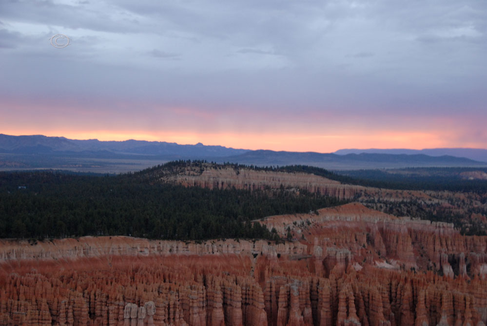
As the storm swirled above the HooDoos, the evening moved in. The moon appeared from behind the clouds as we looked west toward the setting sun. The sky seemed to mimic the red and orange streaks of the HooDoos setting the horizon ablaze between the darkening sky and the shadowed Earth.

Sunset at Bryce Canyon

Sunset at Bryce Canyon

Sunset at Bryce Canyon

Great Basin Bristlecone Pine (Pinus longaeva), Bryce Canyon

Moon over Bryce Canyon

Sunset at Bryce Canyon

Sunset at Bryce Canyon

Sunset at Bryce Canyon
Sunset at Bryce Canyon

Sunset at Bryce Canyon

Sunset at Bryce Canyon

Sunset at Bryce Canyon

Sunset at Bryce Canyon

Sunset at Bryce Canyon
We huddled together and watched twilight take over. Soon, it was dark and we finally climbed back in our car. D got in the driver seat and hunkered down for the night drive. Our next stop, Arches National Park, was hours away. With such a late start, it was going to be a long night on the road.
A good portion of the stretch between parks D was forced to maneuver through some intense road construction, white knuckling between blaze orange barrels in the darkness, trying not to be intimidated by the barrage of oncoming semi-truck traffic. We finally reached Arches around 1:30 am. It was a sticky 75 degrees and we were dead tired. We parked at a wayside along Utah Hwy 313, 2 minutes outside the park, build our mobile bedroom, and promptly passed out.
Westward Wanderlust Soundtrack Day 20 –
Totally dropped the ball on this one. Nothing in my journal for music today.
Pingback: Westward Wanderlust 2012 Trip Stats | inkinthebranches